Un-Mapping combines the fields of Psychogeography, Critical Cartography, and Museum Studies
The key idea is that the map doesn’t ‘reproduce’ space. It ‘produces’ it. If a space is encountered in the form of a map, it will influence how the map-reader will use the space. Cartographic reality supplants spatial reality. Space is produced before it is interacted with.
By critically analysing The Map, we can start to uncover the tools used to produce space. The Map becomes a point of interrogation – a way at shining a light on unspoken assumptions about gallery space. We can begin to see how The Map constructs The Gallery as it wants to be seen, rather than how it is, and how it could be.
The Theory behind my original paper combines a number of directions. Critical Cartographic Scholars. Critical Museologists. Theorists of Space. The heart of the theory is influenced by the work of Emanuela Casti, and her Theory of Cartographic Semiosis.
This Page breaks down the theory and jargon. It should provide a conceptual base for un-mapping gallery space. The next post will cover the practice of Un-Mapping. Once we are comfortable with picking things apart, we will move on to Re-Mapping. Building back our gallery space in new and exciting ways.

Critical Cartography:
Critical Cartography has been a sub-field of cartography since the 80s, really kicking off with The Power of Maps by Wood and Fels in 1993. The spark was the idea that no maps are objective. Even ordinance survey maps were subjective, in the symbols that they used, the names they used for places, the boundaries they drew. This might seem obvious today, but, at it’s heart, critical cartography argues that the act of mapping is an act of power – it is unavoidably political.
For fans of Foucault, there is a large overlap of ideas. Knowledge is power, etc.
The second key idea born of Critical Cartography is that ‘maps construct – not reproduce – the world’ (Wood and Fels, 1993, p.17).
Maps are unavoidably historicised. By this, I mean that the symbols they use are based on a long history of symbols. Take – for instance – the pint glass used to represent a Public House in Open Street Maps. This symbol is used because it shares a history with its intended reader. It is a shortcut to understanding. The symbol suggests a vast amount of knowledge and context.
Wood and Fels argue that the simplification of reality into a set of symbols, spatialised across The Map, gives The Map an illusory power. Rather than mediating reality, it supplants it. We see that symbol for a Pub and our mind constructs what we expect to be there. The Maps statement about the world ‘Here is a Pub’, holds more power than the actual physical environment.
Making a Map is a reality-shaping act of power, which can disrupt or support pre-existing views of space.
If we map a gallery space, rather than reflect it, we produce it, through what we decide to include, and how we decide to depict it.
On the flip side, we can take the map, and use it to see how it produces space, and what this might tell us about how the map’s creator wanted us to experience the space.
So, maps work by tapping into a shared symbolic language in order to produce space, rather than record it. But how do they do that?
The following section outlines some of the ideas found within the scholarship of Emanuela Casti.
Cartographic Semiosis:
Cartographic Semiosis, put simply, is the idea that maps can be read as a text, and that the different parts of the map can be analysed as signs.
Her writing contains a lot of academic vocabulary. For a deeper look, see Chapter III of my original thesis.
In short, Casti argues that two things happen when we create a map. We encode reality twice.
At our first level, we put a name to things. We name physical features in order to separate them from one another. The act of naming encodes key information.
Once we have our names, we encode them again into icons. This act of iconisation adds even more context and information. Crucially, it spacialises our information, putting each icon into a spatialised network with every other icon. This relational web of icons reinforces the power of every icon. By this, I mean that the Pub symbol on our map is next to an icon for a Foot Bridge. Their spatial relation gives us even more context and information about what we are supposed to expect from reality. Our Cartographic Reality becomes more convincing.
However, this double-layer encoding strips away any extraneous information, leaving us with the symbol as cartographic truth. When, in fact, what we started with, wasn’t a truth. It was a territorial conjecture.
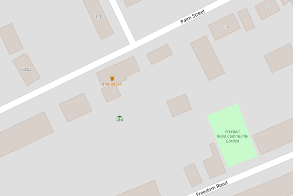
We have a symbol of a pint glass. It tells us that there is a pub there. But what is actually there? A community hub? A place where pints are poured? A monthly creative meet-up? The truth is, from this symbol, we don’t know, we can only assume. For the sake of argument, lets use “The Raven”.
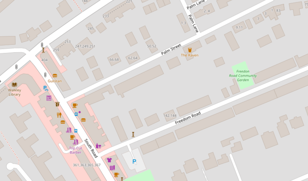
Whoever created the map starts from a territorial conjecture. “The Raven”, with it’s sign outside, its Poe quotes on the walls, and its scuffed carpet inside is named a pub. That is a conjecture. The act of calling it a pub is our first level of encoding. The name – the denomination – ‘Pub’ is full of context. But the act of naming it a Pub strips away any other possibilities of what the space could be. Then, our word, pub, gets transformed into a symbol: a brown glass. It is placed on a map and is imbued with even more context. So, by the time we pick up and read the map, a reality of “The Raven” is created for us, even before we ever walk in the door.
But the drinks aren’t served in brown glasses. The icon is two steps removed from the physical reality of the space. Yet, by encountering the symbol on the map, the social space of the pub is produced, not re-produced, by the map.
Further still, the map, Casti argues, is self-referential. Every occurrence of the pint-glass icon re-affirms the use of every other pint-glass. It’s use to represent a pub is cyclically reaffirmed by every other time it is used.
The Map has reduced and simplified the complexities of “The Raven” into a symbol, an icon, a truth that can be acted on.
My question is, what would happen if you named “The Raven” something else? Community Hub. Warm Space. Occasional Pizza Restaurant. Then, what if you gave that name a different symbol. An insignificant dot, or a complex icon. Then, whoever reads the map is presented with a very different cartographic truth, suggesting a very different territorial conjecture.
So, we can use the map, digging past its layers of icons and names, to reach the assumptions, ideas, and power at the heart of gallery space. To do so, we need a toolkit for Un-Mapping…
Addendum: Psychogeography
This section can be considered supplementary. It will become more relevant when we turn from analysis to creation. To Re-Mapping.
The original psychogeographic core of my thesis got watered down and eventually removed due to a need to fit to word-count, and to the parameters of my MA course. Nevertheless, when talking about maps and the production of space, it is an almost unavoidable topic.
At its heart, psychogeography looks at how the space we enhabit shapes us. How it changes our behaviour and our thoughts. And, conversely, how our internal life changes how we conceive of space.
It is my aim to incorporate Situationist concepts into the final process of un-mapping and re-mapping – a way to interrogate not only how space is produced, but what it means to us.
When we turn to re-mapping, I will re-introduce psychogeography, and it’s relevancy to the project.
Addendum: The Production of Social Space
This section can be also considered supplementary. If you are looking to get straight to Un-Mapping and Re-Mapping space, please skip ahead. If, however, you want to learn how all of these ideas connect up, feel free to continue.
Published in 1974, Henri LeFebvre’s The Production of Social Space is a complex and interesting book. From a Marxist perspective, he seeks to understand how space is created.
By space, he doesn’t just mean the physical distances between things. He means the space as it is socially used. Why is this park considered a park, rather than just a collection of trees and grass. Why is this museum considered a museum, rather than just a building with some old things in it.
LeFebvre argues that social space is produced through three aspects. ‘Spatial Practice’, the way in which we routinely act within space. ‘Representations of Space’, diagrams, sketches – how space would be represented by an architect. And ‘Representational Space’, a shared symbolic understanding of space.
He calls this his ‘perceived-conceived-lived’ triad. We perceive space through the routine actions of others. We conceive of space through blueprints. Yet we Live space through our shared symbolic interaction with it. Our subjective experience of space. While representations of space are concerned with knowledge, representational space is concerned with history and symbolism.
Social Space, the space we perceive, conceive and live in, is produced by these three aspects.
Which brings us back to maps.
The Map allows us a way to study representational space. We are looking at a text imbued with symbols and history. Maps act as a binding concept, producing social space for those who interact with them.
Up next: Un-Mapping: The Toolkit.
